Using GIS and Smart Maps to Streamline School Communication
- By Freddy Cornejo
- 02/02/18
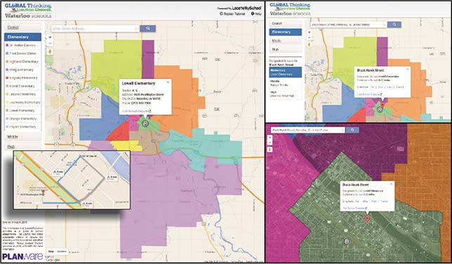
Every day, parents call school and transportation offices to ask questions about where the nearest bus stop is located, or to find out how far their child needs to walk between home and school. Some questions are best answered in person, via email, or over the phone. But questions involving "where" or "which," more often than not, are best answered by providing an address on an easy-to-read school boundary map. With today's geographic information systems (GIS) technology, finding answers to common school boundary and transportation questions should be easy; however, in many cases the answers are not readily available.
Research from the National School Public Relations Association (NSPRA) indicates that there is a positive correlation between family and community involvement in schools and improved academic achievement. These improvements include higher grade-point averages, better scores on standardized tests, and higher attendance rates — and they hold true for students of all ages, from families of all socioeconomic, racial/ethnic and educational backgrounds.
Today, schools use GIS technology, in the form of school locator applications, to strengthen and automate parent-school communication, which also enables administrative staff to become more effective. GIS has also has become an invaluable data visualization tool for administrators during long-range school-planning processes.
Out with the Old, in with the Interactive Maps
As the director of transportation for Brawley Elementary School District in California, part of my job is to make sure each student successfully gets to and from school. We have to calculate bus routes and walking distances for 4,000 students spread across five schools and work with administrators to help determine school boundaries to ensure that students attend the school closest to their homes. Like most districts, we receive new students every week, making it vital that we are ready to provide new parents and our school community the information they need about transportation arrangements and exact school boundaries.
In the past, our department spent hours calculating distances for individual students. To determine school boundaries, administrators and school planners would look at old, static maps or address books. Our challenge with this method was that maps or data can become outdated and are not easily assessable when parents are working to get their child out the door to school.
For this school year, we adopted a school locator application, LocateMySchool to address our boundary and communication concerns. The application dynamically updates school boundaries to reflect new roads, routes and neighborhoods and presents graphic information using color-coded, layered, interactive maps that parents can easily understand. They use their device to type in their home address and a plethora of information, including directions, becomes instantly accessible. Having all this data in one place has streamlined internal and external communication processes in our transportation department and helps us calculate distances to ensure that we meet state transportation compliance standards.
Choosing the Right GIS for You
Of course, every district has different needs, but here are a few essential criteria to consider when looking for a GIS solution.
Accessibility and convenience: Think of the last time you searched for a location. You probably used the GPS on your smartphone. Roughly 77 percent of Americans own a smartphone, so a locator that can be accessed anytime and anywhere is an indispensable tool. Also, consider a platform with a familiar user interface, like Google Maps, that will help all users feel more comfortable.
Today, Brawley parents can get the information they need through any connected device. They enter their address and within seconds view information about which schools their children will attend, the bus stops in the area, and the walking, biking and driving distances and routes between home and school.
Quick and painless implementation: Our implementation took place just before a new school year, so we needed a tool that could be implemented quickly. The entire rollout of the application took about seven days, and the only information that we needed to provide was our current school boundary maps and a list of bus stop locations. As you are searching make sure you find a solution that can align to your timeline.
Planning for the future: Our district is currently planning to build a new school, which can be a controversial and emotional process for the entire school community. We plan to use GIS technology and data to present alternate boundary scenarios in an online format to facilitate planning committee or public review processes. Clearly presented data will help our community to better understand why changes are being made. Additionally, our school locator tool will make communicating the new boundaries to the entire community easier.
Incorporating smart maps and GIS into our daily operations at Brawley has saved our administration hours of answering questions, and strengthened the trust and bond between the school and the outside community.
About the Author
Freddy Cornejo is the manager of transportation at Brawley Elementary School District. You can follow the Brawley USD on Twitter @BrawleyESD.