New Centegix Software Optimizes Incident Response with Dynamic Digital Mapping
- By Kristal Kuykendall
- 05/25/23
Incident response software provider Centegix has introduced a digital mapping solution called Safety Blueprint that provides a “dynamic, multi-layered map of all campus facilities and spaces, including the precise location of all safety assets,” to help district leaders plan better incident management and emergency response, according to a news release.
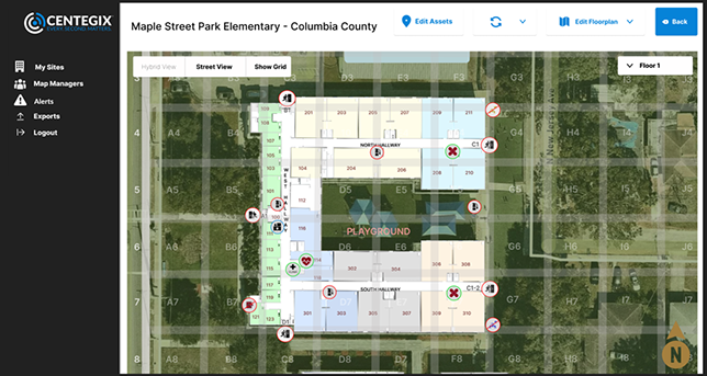
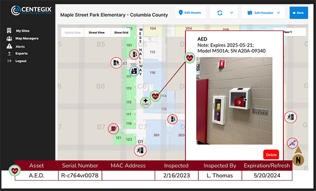
Built for schools and other public sector organizations, Safety Blueprint creates an editable architecture map of all buildings and spaces, with overlays showing the precise locations of safety assets such as AED, fire alarm, first aid kits and extinguishers, cameras, and access control technology points, Centegix said.
Additional layers can be added for multiple departments, for example, to show precise locations of department-level assets any relevant emergency response details. “Users can easily update and edit the architecture map at any time without having to re-engage an architect for every change to a floor plan, large or small,” the company said. “Changes made to the core map are immediately reflected on all existing layers.”
Other potential uses for schools on the Safety Blueprint platform include evacuation and reunification planning, new construction, or temporary building planning and installation, according to the announcement.
Safety Blueprint is now available as a stand-alone solution, and it is integrated withing Centegix’s CrisisAlert wearable panic button solution. The integration with the CrisisAlert platform connects staff badges, facility maps, strobes, intercoms, and screens, to campus first responders and 911 dispatch, Centegix said.
“CrisisAlert is the only incident response solution that delivers precise room-level location information, and we understand how important ‘location’ and mapping situational awareness are to safety planning,” said Centegix CEO Brent Cobb. “Our customers wanted real-time visibility of their facilities and outdoor spaces, including the location of security assets. Live, dynamic mapping capabilities improve situational awareness, response times, planning, and communication, all of which are crucial for maintaining a safe and secure environment in schools, the workplace, or public spaces.”
Other key features of Safety Blueprint, verbatim from Centegix’s announcement, include:
- Scaled architectural drawings for each floor of every building, layered with safety assets as well as with satellite street imagery and gridded overlays, provide real-world visualization for emergency planners and responders.
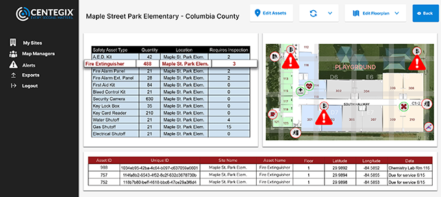
- Precise location of all safety assets, including AED, fire extinguisher, ingress/egress, video surveillance, gas shutoff, water shutoff, and access control, equip campus safety teams with critical information to help mitigate harm during an emergency.
- Site-specific labeling for all internal and external building features, campus spaces, and surrounding roads and safety and security assets; room colors map to indicate grade levels and/or rooms with special needs or dedicated security assets adds another layer of visual communication for responders that may not be familiar with a campus.
- Secure sharing of maps that allows county agencies to receive a log-in from customers and download the current map version or use the Safety Blueprint application for real-time and up-to-date visualization.
“The minute we receive a map in an architectural drawing or PDF is the minute it is out of date!Snapshots in time solve today’s problem, but they create another set of problems and cost. If I have to call an architect or vendor to update maps, then I am wasting time and money,” said Chris Farkas, COO at Hillsborough County Public Schools in Tampa, Florida. “That is why Centegix’s Safety Blueprint is the best of both worlds: we can make updates in real-time and we don’t have to spend money every time we make a change, like consolidating rooms or adding a mobile classroom. The asset management and inventory management capability is icing on the cake.”
Following are sample images from Centegix illustrating the detail of the digital mapping capabilities and the user interface:

About the Author
Kristal Kuykendall is editor, 1105 Media Education Group. She can
be reached at [email protected].